Call Us :   1-403-444-8181
  • Language:

  2D and 3D Line Ties  

Geo-X 2D/3D line tying finds and displays the tie points between 2D and 3D seismic datasets and is used to determine the time, phase and elevation discrepancies (mis-ties) between intersecting datasets.

Features:

  • Finds ties between intersecting 2D lines and jump or near ties between lines that are close together, but not actually intersecting.
  • Ties 3D volumes (and 2D lines into 3Ds) by displaying Time, Phase, Elevation and Fold maps in the overlapping areas. With these attribute maps, individual quality tie points can be picked in the overlap areas.
  • Make time/phase corrections to individual tie points, or to all ties of a dataset or vintage at once.
  • Reads and writes job decks to quickly load (or reload) datasets and tie points.
  • Highly configurable to change display properties and cross correlation parameters.
  • Uses a configurable template system to read SEGY data files that may differ from the standard.
  • Full user documentation with online help available from all windows and dialog boxes.
  • Multi-threaded background processing (same number of background threads as CPU cores) to speed:
    • Reading and indexing of seismic datasets.
    • Updating and drawing tie traces.
    • Computing 3D time, phase and elevation mis-ties.
  • Displays mis-tie information in a table, as bar graphs, as side-by-side traces, and as a symbols on a base map.
  • Displays summary information for each dataset and each vintage.
  • Low memory footprint to handle large datasets and a large number of tie points.

Rekware1

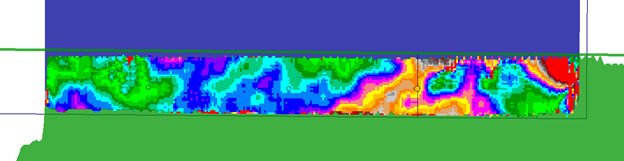
Contoured mis-ties over a 3D overlap

Rekware2

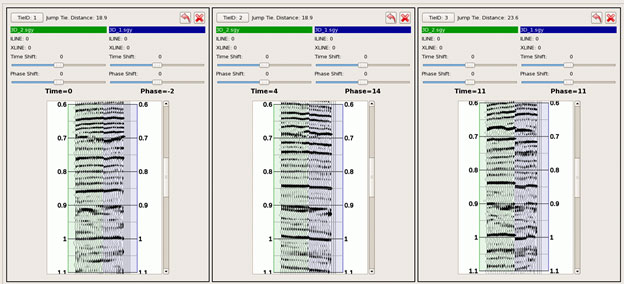
Three tie locations in the overlap zone